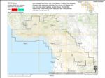
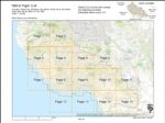
Search Constraints
Number of results to display per page
Search Results
71 results for:
-
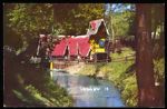
A' Frame Building from Santa's Village Moved to Sorensen's Resort, Hope Valley, CA
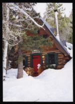 Type:Series:Place:Date Created:1998-03Subject:Santa's Village and Scotts ValleyCall Number:MS 427 and Box 85, Folder 6
 -
Log Building from Santa's Village Moved to Sorensen's Resort in Hope Valley, CA
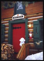 Type:Series:Place:Date Created:1998-03Subject:Santa's Village and Scotts ValleyCall Number:MS 427 and Box 85, Folder 6
 -
Section of Bean Creek Road Just Outside Scotts Valley City Limits Which has Fallen Away Since 1989 Earthquake.
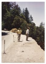 Type:Series:Place:Date Created:approximately 1989Subject:Scotts ValleyCall Number:MS 427 and Box 111, Folder 6
 -
Section of Bean Creek Road Just Outside Scotts Valley City Limits Which has Fallen Away Since 1989 Earthquake.
 Type:Series:Place:Date Created:approximately 1989Subject:Scotts ValleyCall Number:MS 427 and Box 111, Folder 6
 -
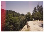
Near Section of Bean Creek Road Which has Fallen Away Since 1989 Earthquake___
 Type:Series:Place:Date Created:approximately 1989Subject:Scotts ValleyCall Number:MS 427 and Box 111, Folder 6
 -
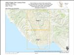
1974-Color San Andreas Fault Zone Flight
 Variant Title:Creator:Type:Place:Date Created:1974Subject:Santa Cruz County, San Andreas Fault, Castroville, Capitola, Watsonville, Aptos, San Juan Bautista, Scotts Valley, and Soquel
 -
1963-E Santa Cruz County Flight CJA
 Variant Title:Type:Place:Santa Cruz County, Ben Lomond, Watsonville Municipal Airport, Capitola, Felton, Santa Cruz, Santa Clara, Santa Cruz Small Craft Harbor, The Forest of Nisene Marks State Park, University of California Santa Cruz, San Lorenzo River Mouth, San Lorenzo Valley, Live Oak, Pogonip, San Mateo, Greyhound Rock, Natural Bridges State Beach, La Selva Beach, Watsonville, Corralitos, Scotts Valley, Lighthouse Field, Monterey County, Waddell Creek, Wilder Ranch State Park, Soquel Point, Big Basin Redwoods State Park, Pajaro Valley, Boulder Creek, and AptosDate Created:1963Subject:Santa Cruz County, Ben Lomond, Watsonville Municipal Airport, Capitola, Felton, Santa Cruz, Santa Clara, Santa Cruz Small Craft Harbor, The Forest of Nisene Marks State Park, University of California Santa Cruz, San Lorenzo River Mouth, San Lorenzo Valley, Live Oak, Pogonip, San Mateo, Greyhound Rock, Natural Bridges State Beach, La Selva Beach, Watsonville, Corralitos, Scotts Valley, Lighthouse Field, Monterey County, Waddell Creek, Wilder Ranch State Park, Soquel Point, Big Basin Redwoods State Park, Pajaro Valley, Boulder Creek, and AptosCall Number:1963-E
 -
Santa's Village Built in Scott's Valley About 1952
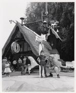 Variant Title:Type:Series:Place:Date Created:approximately 1952-1960Subject:Santa's Village and Scotts ValleyCall Number:MS 427 and Box 85, Folder 6
 -
Santa's Village California - Mill Wheel Toy Factory
 Type:Series:Place:Date Created:approximately 1952-1960Subject:Santa's Village and Scotts ValleyCall Number:MS 427 and Box 85, Folder 6
 -
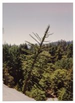
"Trees of Mystery"
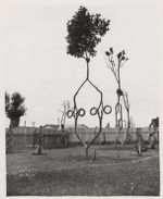 Title:Type:Series:People:Place:Date Created:approximately 1950-1960Subject:Tree Circus and Scotts ValleyCall Number:MS 427 and Box 85, Folder 6
 -
Axel Erlander [Erlandson], Creator of Tree Circus
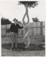 Variant Title:Type:Series:People:Place:Date Created:approximately 1950-1960Subject:Tree Circus and Scotts ValleyCall Number:MS 427 and Box 85, Folder 6
 -
1956-B Santa Cruz County Flight CJA
 Variant Title:Creator:Type:Place:Santa Cruz County, Ben Lomond, Watsonville Municipal Airport, Capitola, Felton, Santa Cruz, Santa Clara, San Benito, Point Año Nuevo, The Forest of Nisene Marks State Park, University of California Santa Cruz, San Lorenzo River Mouth, Antonelli Pond, San Lorenzo Valley, Elkhorn Slough, Pogonip, San Mateo, Greyhound Rock, Natural Bridges State Beach, La Selva Beach, Watsonville, Corralitos, Scotts Valley, Lighthouse Field, Monterey County, Wilder Ranch State Park, Soquel Point, Big Basin Redwoods State Park, Pajaro Valley, Boulder Creek, Waddell Creek Beach, Santa Cruz Small Craft Harbor, Live Oak, and AptosDate Created:1956Subject:Santa Cruz County, Ben Lomond, Watsonville Municipal Airport, Capitola, Felton, Santa Cruz, Santa Clara, San Benito, Point Año Nuevo, The Forest of Nisene Marks State Park, University of California Santa Cruz, San Lorenzo River Mouth, Antonelli Pond, San Lorenzo Valley, Elkhorn Slough, Pogonip, San Mateo, Greyhound Rock, Natural Bridges State Beach, La Selva Beach, Watsonville, Corralitos, Scotts Valley, Lighthouse Field, Monterey County, Wilder Ranch State Park, Soquel Point, Big Basin Redwoods State Park, Pajaro Valley, Boulder Creek, Waddell Creek Beach, Santa Cruz Small Craft Harbor, Live Oak, and AptosCall Number:1956-B
 -
Aerial View of a Mountain Fire
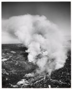 Type:Series:Place:Topic:Date Created:1954-07-30Subject:Fires and Scotts ValleyCall Number:MS 427 and Box 30, Folder 5
 -
1948 U.S. Forest Service Flight CDF-5
 Variant Title:Creator:Type:Place:Monterey County, Ben Lomond, Los Gatos, Big Basin Redwoods State Park, Capitola, Pajaro Valley, Santa Cruz, Palo Alto, Santa Cruz Small Craft Harbor, The Forest of Nisene Marks State Park, University of California Santa Cruz, San Lorenzo River Mouth, Antonelli Pond, San Lorenzo Valley, Live Oak, Pogonip, San Mateo, Greyhound Rock, Natural Bridges State Beach, La Selva Beach, Watsonville, Aptos, Almaden Canyon, Scotts Valley, Lighthouse Field, Santa Cruz County, Watsonville Municipal Airport, Wilder Ranch State Park, Soquel Point, Felton, Boulder Creek, Santa Clara, Waddell Creek Beach, Point Año Nuevo, Pescadero, and CorralitosDate Created:1948Description:Subject:Monterey County, Ben Lomond, Los Gatos, Big Basin Redwoods State Park, Capitola, Pajaro Valley, Santa Cruz, Palo Alto, Santa Cruz Small Craft Harbor, The Forest of Nisene Marks State Park, University of California Santa Cruz, San Lorenzo River Mouth, Antonelli Pond, San Lorenzo Valley, Live Oak, Pogonip, San Mateo, Greyhound Rock, Natural Bridges State Beach, La Selva Beach, Watsonville, Aptos, Almaden Canyon, Scotts Valley, Lighthouse Field, Santa Cruz County, Watsonville Municipal Airport, Wilder Ranch State Park, Soquel Point, Felton, Boulder Creek, Santa Clara, Waddell Creek Beach, Point Año Nuevo, Pescadero, and CorralitosCall Number:1948
 -
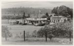
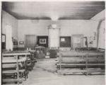
Tabernacle Mission Springs Conference Grounds Santa Cruz, California
 Type:Place:Topic:Date Created:approximately 1940-1950Subject:Spiritual retreat centers and Scotts ValleyCall Number:MS 427 and Box 94, Folder 4
 -
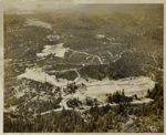
Scotts Valley Area & Sky Park Airport When Under Construction, 1946 (Looking Toward Ben Lomond)
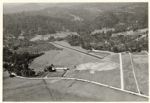 Title:Type:Series:Place:Topic:Date Created:1946Subject:Airports and Scotts ValleyCall Number:MS 427 and Box 118, Folder 5
 -
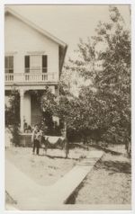
Camp Evers Santa Cruz Mts. Calif.
 Type:Series:Place:Date Created:approximately 1938-1948Subject:Scotts ValleyCall Number:MS 427 and Box 111, Folder 6
 -
1943 Santa Cruz County Flight CJA
 Variant Title:Creator:Type:Place:Santa Cruz County, Ben Lomond, Big Basin Redwoods State Park, Capitola, Boulder Creek, Santa Cruz, Santa Cruz Small Craft Harbor, University of California Santa Cruz, San Lorenzo River Mouth, San Lorenzo Valley, Live Oak, Pogonip, Greyhound Rock, Natural Bridges State Beach, Scotts Valley, Lighthouse Field, Soquel Point, Felton, and Waddell Creek BeachDate Created:1943Subject:Santa Cruz County, Ben Lomond, Big Basin Redwoods State Park, Capitola, Boulder Creek, Santa Cruz, Santa Cruz Small Craft Harbor, University of California Santa Cruz, San Lorenzo River Mouth, San Lorenzo Valley, Live Oak, Pogonip, Greyhound Rock, Natural Bridges State Beach, Scotts Valley, Lighthouse Field, Soquel Point, Felton, and Waddell Creek BeachCall Number:1943
 -
Bob McElroy
 Title:Creator:Type:Series:Place:Date Created:1941-06-01Subject:Scotts ValleyCall Number:MS 427 and Box 68, Folder 1
 -
1940 Santa Cruz County Flight C-6472
 Creator:Type:Place:Date Created:[1940]Subject:Lighthouse Field, Wilder Ranch State Park, Felton, Santa Cruz, Santa Cruz Small Craft Harbor, University of California Santa Cruz, San Lorenzo River Mouth, Antonelli Pond, San Lorenzo Valley, Live Oak, Pogonip, Natural Bridges State Beach, Scotts Valley, Santa Cruz County, and Soquel PointCall Number:1940
 -
1940-A Santa Cruz County Flight SLR
 Variant Title:Type:Place:Date Created:[1940]Subject:Lighthouse Field, Ben Lomond, Boulder Creek, Santa Cruz, San Lorenzo River, University of California Santa Cruz, San Lorenzo River Mouth, San Lorenzo Valley, Pogonip, Scotts Valley, Santa Cruz County, and FeltonCall Number:1940-A
 -
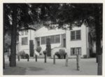
Old Scotts Valley School
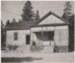 Title:Type:Series:Place:Date Created:1940-12Description:Subject:Scotts ValleyCall Number:MS 427 and Box 100, Folder 3
 -
Old Scotts Valley School
 Title:Type:Series:Place:Date Created:1940-12Description:Subject:Scotts ValleyCall Number:MS 427 and Box 100, Folder 3
 -
Top - Graham Hill Road; Bottom - Mt. Hermon - Felton Road
 Variant Title:Type:Series:Place:Date Created:approximately 1930-1940Subject:Scotts ValleyCall Number:MS 427 and Box 111, Folder 6