Search Constraints
Filtering by:
Collection
UC Santa Cruz Aerial Photographs Collection
Remove constraint Collection: UC Santa Cruz Aerial Photographs Collection
Creator
Earthdata (Firm)
Remove constraint Creator: Earthdata (Firm)
Place
Pajaro River
Remove constraint Place: Pajaro River
Number of results to display per page
Search Results
7 results for:
-
1974 Color San Andreas Fault Zone Flight 13-251
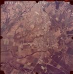 Creator:Type:Place:Date Created:1974Subject:Pajaro River and Watsonville Municipal Airport
 -
1974 Color San Andreas Fault Zone Flight 13-250
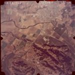 Creator:Type:Place:Date Created:1974Subject:Pajaro River
 -
1974 Color San Andreas Fault Zone Flight 13-213
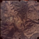 Creator:Type:Place:Date Created:1974Subject:Soda Lake, A.R. Wilson Quarry, and Pajaro River
 -
1974 Color San Andreas Fault Zone Flight 13-212
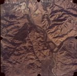 Creator:Type:Place:Date Created:1974Subject:Soda Lake, A.R. Wilson Quarry, and Pajaro River
 -
1974 Color San Andreas Fault Zone Flight 13-211
 Creator:Type:Place:Date Created:1974Subject:Pajaro River
 -
1974 Color San Andreas Fault Zone Flight 10-165
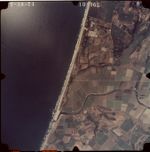 Creator:Type:Place:Date Created:1974Subject:Sunset State Beach and Pajaro River
 -
1974 Color San Andreas Fault Zone Flight 10-164
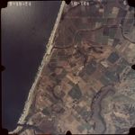 Creator:Type:Date Created:1974Subject:Palm Beach (historical), Elkhorn Slough, Pajaro River, and Pajaro Dunes Condominiums
Limit your search
- 1974-Color San Andreas Fault Zone Flight7
- UC Santa Cruz Aerial Photographs Collection[remove]7