Skip to Content
Toggle navigation
UC Santa Cruz
University Library
Contact Us
Browse Collections
Digital Collections
Photographs, audio recordings, publications, and more from our Special Collections & Archives
Search
Search
Search Constraints
Start Over
Filtering by:
Collection
1966-D San Andreas Fault Zone Flight
Remove constraint Collection: 1966-D San Andreas Fault Zone Flight
Sort by relevance
relevance
Title ▼
Title ▲
Date Created ▼
Date Created ▲
Number of results to display per page
24 per page
10
per page
20
per page
24
per page
50
per page
100
per page
View results as:
List
Gallery
Masonry
Search Results
1238 results for:
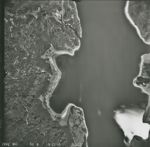
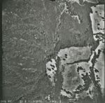
1966-D San Andreas Fault Zone Flight 2459-WRD
Title:
1966-D San Andreas Fault Zone Flight 2459-WRD
Creator:
Pacific Western Aerial Surveys
Type:
Image
Date Created:
[1966]
Description:
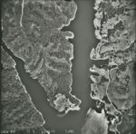
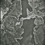
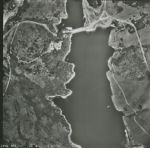
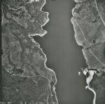
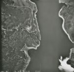
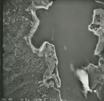
San Andreas Fault Zone, from San Francisco County line to Monterey County- San Luis Obispo County line. Flight has a total of approximately 8500 images
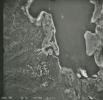
1966-D San Andreas Fault Zone Flight 2458-WRD
Title:
1966-D San Andreas Fault Zone Flight 2458-WRD
Creator:
Pacific Western Aerial Surveys
Type:
Image
Date Created:
[1966]
Description:
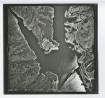
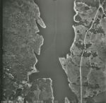
San Andreas Fault Zone, from San Francisco County line to Monterey County- San Luis Obispo County line. Flight has a total of approximately 8500 images
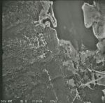
1966-D San Andreas Fault Zone Flight 2457-WRD
Title:
1966-D San Andreas Fault Zone Flight 2457-WRD
Creator:
Pacific Western Aerial Surveys
Type:
Image
Date Created:
[1966]
Description:
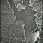
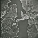
San Andreas Fault Zone, from San Francisco County line to Monterey County- San Luis Obispo County line. Flight has a total of approximately 8500 images
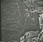
1966-D San Andreas Fault Zone Flight 2456-WRD
Title:
1966-D San Andreas Fault Zone Flight 2456-WRD
Creator:
Pacific Western Aerial Surveys
Type:
Image
Date Created:
[1966]
Description:
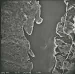
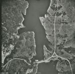
San Andreas Fault Zone, from San Francisco County line to Monterey County- San Luis Obispo County line. Flight has a total of approximately 8500 images
1966-D San Andreas Fault Zone Flight 2455-WRD
Title:
1966-D San Andreas Fault Zone Flight 2455-WRD
Creator:
Pacific Western Aerial Surveys
Type:
Image
Date Created:
[1966]
Description:
San Andreas Fault Zone, from San Francisco County line to Monterey County- San Luis Obispo County line. Flight has a total of approximately 8500 images
1966-D San Andreas Fault Zone Flight 2453-WRD
Title:
1966-D San Andreas Fault Zone Flight 2453-WRD
Creator:
Pacific Western Aerial Surveys
Type:
Image
Date Created:
[1966]
Description:
San Andreas Fault Zone, from San Francisco County line to Monterey County- San Luis Obispo County line. Flight has a total of approximately 8500 images
1966-D San Andreas Fault Zone Flight 2454-WRD
Title:
1966-D San Andreas Fault Zone Flight 2454-WRD
Creator:
Pacific Western Aerial Surveys
Type:
Image
Date Created:
[1966]
Description:
San Andreas Fault Zone, from San Francisco County line to Monterey County- San Luis Obispo County line. Flight has a total of approximately 8500 images
1966-D San Andreas Fault Zone Flight 2452-WRD
Title:
1966-D San Andreas Fault Zone Flight 2452-WRD
Creator:
Pacific Western Aerial Surveys
Type:
Image
Date Created:
[1966]
Description:
San Andreas Fault Zone, from San Francisco County line to Monterey County- San Luis Obispo County line. Flight has a total of approximately 8500 images
1966-D San Andreas Fault Zone Flight 2451-WRD
Title:
1966-D San Andreas Fault Zone Flight 2451-WRD
Creator:
Pacific Western Aerial Surveys
Type:
Image
Date Created:
[1966]
Description:
San Andreas Fault Zone, from San Francisco County line to Monterey County- San Luis Obispo County line. Flight has a total of approximately 8500 images
1966-D San Andreas Fault Zone Flight 2450-WRD
Title:
1966-D San Andreas Fault Zone Flight 2450-WRD
Creator:
Pacific Western Aerial Surveys
Type:
Image
Date Created:
[1966]
Description:
San Andreas Fault Zone, from San Francisco County line to Monterey County- San Luis Obispo County line. Flight has a total of approximately 8500 images
1966-D San Andreas Fault Zone Flight 2449-WRD
Title:
1966-D San Andreas Fault Zone Flight 2449-WRD
Creator:
Pacific Western Aerial Surveys
Type:
Image
Date Created:
[1966]
Description:
San Andreas Fault Zone, from San Francisco County line to Monterey County- San Luis Obispo County line. Flight has a total of approximately 8500 images
1966-D San Andreas Fault Zone Flight 2447-WRD
Title:
1966-D San Andreas Fault Zone Flight 2447-WRD
Creator:
Pacific Western Aerial Surveys
Type:
Image
Date Created:
[1966]
Description:
San Andreas Fault Zone, from San Francisco County line to Monterey County- San Luis Obispo County line. Flight has a total of approximately 8500 images
1966-D San Andreas Fault Zone Flight 2448-WRD
Title:
1966-D San Andreas Fault Zone Flight 2448-WRD
Creator:
Pacific Western Aerial Surveys
Type:
Image
Date Created:
[1966]
Description:
San Andreas Fault Zone, from San Francisco County line to Monterey County- San Luis Obispo County line. Flight has a total of approximately 8500 images
1966-D San Andreas Fault Zone Flight 2446-WRD
Title:
1966-D San Andreas Fault Zone Flight 2446-WRD
Creator:
Pacific Western Aerial Surveys
Type:
Image
Date Created:
[1966]
Description:
San Andreas Fault Zone, from San Francisco County line to Monterey County- San Luis Obispo County line. Flight has a total of approximately 8500 images
1966-D San Andreas Fault Zone Flight 2444-WRD
Title:
1966-D San Andreas Fault Zone Flight 2444-WRD
Creator:
Pacific Western Aerial Surveys
Type:
Image
Date Created:
[1966]
Description:
San Andreas Fault Zone, from San Francisco County line to Monterey County- San Luis Obispo County line. Flight has a total of approximately 8500 images
1966-D San Andreas Fault Zone Flight 2445-WRD
Title:
1966-D San Andreas Fault Zone Flight 2445-WRD
Creator:
Pacific Western Aerial Surveys
Type:
Image
Date Created:
[1966]
Description:
San Andreas Fault Zone, from San Francisco County line to Monterey County- San Luis Obispo County line. Flight has a total of approximately 8500 images
1966-D San Andreas Fault Zone Flight 2443-WRD
Title:
1966-D San Andreas Fault Zone Flight 2443-WRD
Creator:
Pacific Western Aerial Surveys
Type:
Image
Date Created:
[1966]
Description:
San Andreas Fault Zone, from San Francisco County line to Monterey County- San Luis Obispo County line. Flight has a total of approximately 8500 images
1966-D San Andreas Fault Zone Flight 2441-WRD
Title:
1966-D San Andreas Fault Zone Flight 2441-WRD
Creator:
Pacific Western Aerial Surveys
Type:
Image
Date Created:
[1966]
Description:
San Andreas Fault Zone, from San Francisco County line to Monterey County- San Luis Obispo County line. Flight has a total of approximately 8500 images
1966-D San Andreas Fault Zone Flight 2442-WRD
Title:
1966-D San Andreas Fault Zone Flight 2442-WRD
Creator:
Pacific Western Aerial Surveys
Type:
Image
Date Created:
[1966]
Description:
San Andreas Fault Zone, from San Francisco County line to Monterey County- San Luis Obispo County line. Flight has a total of approximately 8500 images
1966-D San Andreas Fault Zone Flight 2440-WRD
Title:
1966-D San Andreas Fault Zone Flight 2440-WRD
Creator:
Pacific Western Aerial Surveys
Type:
Image
Date Created:
[1966]
Description:
San Andreas Fault Zone, from San Francisco County line to Monterey County- San Luis Obispo County line. Flight has a total of approximately 8500 images
1966-D San Andreas Fault Zone Flight 2439-WRD
Title:
1966-D San Andreas Fault Zone Flight 2439-WRD
Creator:
Pacific Western Aerial Surveys
Type:
Image
Date Created:
[1966]
Description:
San Andreas Fault Zone, from San Francisco County line to Monterey County- San Luis Obispo County line. Flight has a total of approximately 8500 images
1966-D San Andreas Fault Zone Flight 2438-WRD
Title:
1966-D San Andreas Fault Zone Flight 2438-WRD
Creator:
Pacific Western Aerial Surveys
Type:
Image
Date Created:
[1966]
Description:
San Andreas Fault Zone, from San Francisco County line to Monterey County- San Luis Obispo County line. Flight has a total of approximately 8500 images
1966-D San Andreas Fault Zone Flight 2437-WRD
Title:
1966-D San Andreas Fault Zone Flight 2437-WRD
Creator:
Pacific Western Aerial Surveys
Type:
Image
Date Created:
[1966]
Description:
San Andreas Fault Zone, from San Francisco County line to Monterey County- San Luis Obispo County line. Flight has a total of approximately 8500 images
1966-D San Andreas Fault Zone Flight 2436-WRD
Title:
1966-D San Andreas Fault Zone Flight 2436-WRD
Creator:
Pacific Western Aerial Surveys
Type:
Image
Date Created:
[1966]
Description:
San Andreas Fault Zone, from San Francisco County line to Monterey County- San Luis Obispo County line. Flight has a total of approximately 8500 images
Previous
1
2
…
12
13
14
15
16
17
18
19
20
…
51
52
Next
Show Filters
Limit your search
Creator
Pacific Western Aerial Surveys
988
Type
Image
1,238
Collection
1966-D San Andreas Fault Zone Flight
[remove]
1,238
UC Santa Cruz Aerial Photographs Collection
1,238
×
Digital Collections Feedback