Skip to Content
Toggle navigation
UC Santa Cruz
University Library
Contact Us
Browse Collections
Digital Collections
Photographs, audio recordings, publications, and more from our Special Collections & Archives
Search
Search
Search Constraints
Start Over
Filtering by:
Creator
Pacific Western Aerial Surveys
Remove constraint Creator: Pacific Western Aerial Surveys
Sort by relevance
relevance
Title ▼
Title ▲
Date Created ▼
Date Created ▲
Number of results to display per page
24 per page
10
per page
20
per page
24
per page
50
per page
100
per page
View results as:
List
Gallery
Masonry
Search Results
989 results for:
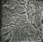
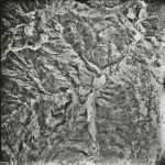
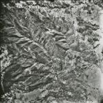
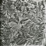
1966-D San Andreas Fault Zone Flight 2050-WRD
Title:
1966-D San Andreas Fault Zone Flight 2050-WRD
Creator:
Pacific Western Aerial Surveys
Type:
Image
Date Created:
[1966]
Description:
San Andreas Fault Zone, from San Francisco County line to Monterey County- San Luis Obispo County line. Flight has a total of approximately 8500 images
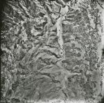
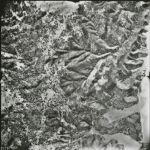
1966-D San Andreas Fault Zone Flight 2051-WRD
Title:
1966-D San Andreas Fault Zone Flight 2051-WRD
Creator:
Pacific Western Aerial Surveys
Type:
Image
Date Created:
[1966]
Description:
San Andreas Fault Zone, from San Francisco County line to Monterey County- San Luis Obispo County line. Flight has a total of approximately 8500 images
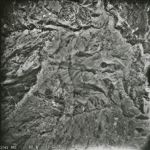
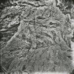
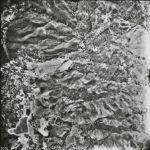
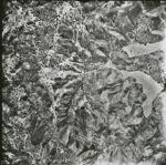
1966-D San Andreas Fault Zone Flight 2049-WRD
Title:
1966-D San Andreas Fault Zone Flight 2049-WRD
Creator:
Pacific Western Aerial Surveys
Type:
Image
Date Created:
[1966]
Description:
San Andreas Fault Zone, from San Francisco County line to Monterey County- San Luis Obispo County line. Flight has a total of approximately 8500 images
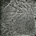
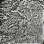
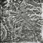
1966-D San Andreas Fault Zone Flight 2048-WRD
Title:
1966-D San Andreas Fault Zone Flight 2048-WRD
Creator:
Pacific Western Aerial Surveys
Type:
Image
Date Created:
[1966]
Description:
San Andreas Fault Zone, from San Francisco County line to Monterey County- San Luis Obispo County line. Flight has a total of approximately 8500 images
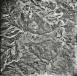
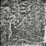
1966-D San Andreas Fault Zone Flight 2047-WRD
Title:
1966-D San Andreas Fault Zone Flight 2047-WRD
Creator:
Pacific Western Aerial Surveys
Type:
Image
Date Created:
[1966]
Description:
San Andreas Fault Zone, from San Francisco County line to Monterey County- San Luis Obispo County line. Flight has a total of approximately 8500 images
1966-D San Andreas Fault Zone Flight 2046-WRD
Title:
1966-D San Andreas Fault Zone Flight 2046-WRD
Creator:
Pacific Western Aerial Surveys
Type:
Image
Date Created:
[1966]
Description:
San Andreas Fault Zone, from San Francisco County line to Monterey County- San Luis Obispo County line. Flight has a total of approximately 8500 images
1966-D San Andreas Fault Zone Flight 2045-WRD
Title:
1966-D San Andreas Fault Zone Flight 2045-WRD
Creator:
Pacific Western Aerial Surveys
Type:
Image
Date Created:
[1966]
Description:
San Andreas Fault Zone, from San Francisco County line to Monterey County- San Luis Obispo County line. Flight has a total of approximately 8500 images
1966-D San Andreas Fault Zone Flight 2044-WRD
Title:
1966-D San Andreas Fault Zone Flight 2044-WRD
Creator:
Pacific Western Aerial Surveys
Type:
Image
Date Created:
[1966]
Description:
San Andreas Fault Zone, from San Francisco County line to Monterey County- San Luis Obispo County line. Flight has a total of approximately 8500 images
1966-D San Andreas Fault Zone Flight 2043-WRD
Title:
1966-D San Andreas Fault Zone Flight 2043-WRD
Creator:
Pacific Western Aerial Surveys
Type:
Image
Date Created:
[1966]
Description:
San Andreas Fault Zone, from San Francisco County line to Monterey County- San Luis Obispo County line. Flight has a total of approximately 8500 images
1966-D San Andreas Fault Zone Flight 2042-WRD
Title:
1966-D San Andreas Fault Zone Flight 2042-WRD
Creator:
Pacific Western Aerial Surveys
Type:
Image
Date Created:
[1966]
Description:
San Andreas Fault Zone, from San Francisco County line to Monterey County- San Luis Obispo County line. Flight has a total of approximately 8500 images
1966-D San Andreas Fault Zone Flight 2041-WRD
Title:
1966-D San Andreas Fault Zone Flight 2041-WRD
Creator:
Pacific Western Aerial Surveys
Type:
Image
Date Created:
[1966]
Description:
San Andreas Fault Zone, from San Francisco County line to Monterey County- San Luis Obispo County line. Flight has a total of approximately 8500 images
1966-D San Andreas Fault Zone Flight 2040-WRD
Title:
1966-D San Andreas Fault Zone Flight 2040-WRD
Creator:
Pacific Western Aerial Surveys
Type:
Image
Date Created:
[1966]
Description:
San Andreas Fault Zone, from San Francisco County line to Monterey County- San Luis Obispo County line. Flight has a total of approximately 8500 images
1966-D San Andreas Fault Zone Flight 2039-WRD
Title:
1966-D San Andreas Fault Zone Flight 2039-WRD
Creator:
Pacific Western Aerial Surveys
Type:
Image
Date Created:
[1966]
Description:
San Andreas Fault Zone, from San Francisco County line to Monterey County- San Luis Obispo County line. Flight has a total of approximately 8500 images
1966-D San Andreas Fault Zone Flight 2038-WRD
Title:
1966-D San Andreas Fault Zone Flight 2038-WRD
Creator:
Pacific Western Aerial Surveys
Type:
Image
Date Created:
[1966]
Description:
San Andreas Fault Zone, from San Francisco County line to Monterey County- San Luis Obispo County line. Flight has a total of approximately 8500 images
1966-D San Andreas Fault Zone Flight 2037-WRD
Title:
1966-D San Andreas Fault Zone Flight 2037-WRD
Creator:
Pacific Western Aerial Surveys
Type:
Image
Date Created:
[1966]
Description:
San Andreas Fault Zone, from San Francisco County line to Monterey County- San Luis Obispo County line. Flight has a total of approximately 8500 images
1966-D San Andreas Fault Zone Flight 2036-WRD
Title:
1966-D San Andreas Fault Zone Flight 2036-WRD
Creator:
Pacific Western Aerial Surveys
Type:
Image
Date Created:
[1966]
Description:
San Andreas Fault Zone, from San Francisco County line to Monterey County- San Luis Obispo County line. Flight has a total of approximately 8500 images
1966-D San Andreas Fault Zone Flight 2035-WRD
Title:
1966-D San Andreas Fault Zone Flight 2035-WRD
Creator:
Pacific Western Aerial Surveys
Type:
Image
Date Created:
[1966]
Description:
San Andreas Fault Zone, from San Francisco County line to Monterey County- San Luis Obispo County line. Flight has a total of approximately 8500 images
1966-D San Andreas Fault Zone Flight 2034-WRD
Title:
1966-D San Andreas Fault Zone Flight 2034-WRD
Creator:
Pacific Western Aerial Surveys
Type:
Image
Date Created:
[1966]
Description:
San Andreas Fault Zone, from San Francisco County line to Monterey County- San Luis Obispo County line. Flight has a total of approximately 8500 images
1966-D San Andreas Fault Zone Flight 2032-WRD
Title:
1966-D San Andreas Fault Zone Flight 2032-WRD
Creator:
Pacific Western Aerial Surveys
Type:
Image
Date Created:
[1966]
Description:
San Andreas Fault Zone, from San Francisco County line to Monterey County- San Luis Obispo County line. Flight has a total of approximately 8500 images
1966-D San Andreas Fault Zone Flight 2033-WRD
Title:
1966-D San Andreas Fault Zone Flight 2033-WRD
Creator:
Pacific Western Aerial Surveys
Type:
Image
Date Created:
[1966]
Description:
San Andreas Fault Zone, from San Francisco County line to Monterey County- San Luis Obispo County line. Flight has a total of approximately 8500 images
1966-D San Andreas Fault Zone Flight 2031-WRD
Title:
1966-D San Andreas Fault Zone Flight 2031-WRD
Creator:
Pacific Western Aerial Surveys
Type:
Image
Date Created:
[1966]
Description:
San Andreas Fault Zone, from San Francisco County line to Monterey County- San Luis Obispo County line. Flight has a total of approximately 8500 images
1966-D San Andreas Fault Zone Flight 2030-WRD
Title:
1966-D San Andreas Fault Zone Flight 2030-WRD
Creator:
Pacific Western Aerial Surveys
Type:
Image
Date Created:
[1966]
Description:
San Andreas Fault Zone, from San Francisco County line to Monterey County- San Luis Obispo County line. Flight has a total of approximately 8500 images
1966-D San Andreas Fault Zone Flight 2029-WRD
Title:
1966-D San Andreas Fault Zone Flight 2029-WRD
Creator:
Pacific Western Aerial Surveys
Type:
Image
Date Created:
[1966]
Description:
San Andreas Fault Zone, from San Francisco County line to Monterey County- San Luis Obispo County line. Flight has a total of approximately 8500 images
1966-D San Andreas Fault Zone Flight 2028-WRD
Title:
1966-D San Andreas Fault Zone Flight 2028-WRD
Creator:
Pacific Western Aerial Surveys
Type:
Image
Date Created:
[1966]
Description:
San Andreas Fault Zone, from San Francisco County line to Monterey County- San Luis Obispo County line. Flight has a total of approximately 8500 images
Previous
1
2
…
16
17
18
19
20
21
22
23
24
…
41
42
Next
Show Filters
Limit your search
Creator
Pacific Western Aerial Surveys
[remove]
989
Type
Image
988
Collection
1
Place
Los Gatos
1
Monterey County
1
Palo Alto
1
San Andreas Fault
1
San Benito
1
more
Places
»
Collection
UC Santa Cruz Aerial Photographs Collection
989
1966-D San Andreas Fault Zone Flight
988
×
Digital Collections Feedback